Equinoxsdrones

Aerial Drone Surveying and Mapping

Our stellar Aerial Drone Surveying / Mapping techniques are here to promote your treasured business to the next level by preserving time and money.
Aerial Surveying and Mapping Services in Bangalore

Drone Surveying / Mapping in India

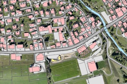
Equinox’s Drones strives to provide clear-cut Aerial Drone Surveying/Mapping services across India. From having served the Government and Private sector in Land Surveying, Aerial Surveying for Land Management & Development, Land Slope monitoring, Stockpile volumetric measurements, Designing smart cities, Mapping greenfield projects, etc. our experience remains unsurpassed. Equinox’s Drones prioritizes quality and, thus, perpetually continues to achieve highly accurate topographic maps with Centimeter level Accuracy at any given time. Adorned with state-of-the-art surveying drones and a team of expert licensed pilots, our clients can access deliverables with greater speed, thereby facilitating more nimble decision-making processes.

Deliverables we provide:

  • Orthomosaic maps
  • 3D point cloud
  • Digital surface models (DSM)
  • Digital Elevation Model (DEM)
  • Digital Terrain Model (DTM)
  • CONTOUR MAPS
  • 3D Textured Maps

We can help with

Land Surveying

Our nationwide and tailored service of drone surveying enables us to procure precise topographic maps and 3D models of areas with unaccessible evidence. Extensive land surveys and topographical surveys permit the most definite representation of cadastral maps, immediately and in a hassle-free manner. Our GIS crew then post-processes the data with photogrammetry software to generate deliverables like a detailed Digital Elevation Model (DEM), Digital Terrain Model (DTM), contours, brake lines, ortho-mosaic/ortho-imagery, interactive 3D Mode, and 3D reconstructions of land sites or buildings.

Land Management & Development

We encourage organizations to adopt topographic surveys for a more thoughtful land planning and management process. Providing well-defined and more expeditious data, our background in land management and development has supported several private and government agencies for secure pre-construction planning. We steer our attention to site scouting, allotment, planning, design, and the concluding construction of roads, buildings, and utilities. Accurate aerial surveying/ mapping and topographical mapping at frequent intervals of time retain the course of construction and plans, at pocket-friendly costs.

Stockpile Volumetric Measurements

Drones are a popular and conventional method of Stockpile measurements in the industry. Our pilots can conduct Stockpile analysis with our highly exquisite surveying drones and capture extensive topographic data points that traditional methods cannot detect due to their irregular shapes. Surveying can capture and depict all these variations as shape’s actual volume, and not just its estimate. We strategically and efficiently deliver photogrammetric information through Contouring, Digital Surface Models, stockpiles such as waste, mines, inventory, agriculture, etc., and volume measurements with a nearly 99% accuracy rate.

Slope Monitoring

Slope failure represents a significant geological risk, and early detection is crucial to ensure safety. Our team of experts employs GIS mapping techniques to effectively identify ground surface steepness, utilizing the Digital Terrain Model (DTM) and Digital Surface Model (DSM) as part of the slope monitoring process. This information, along with the LIDAR survey data, is essential for slope monitoring, landslide mitigation, and prevention of slope failure. Aerial survey mapping is an added valuable tool used by specialists to track the Earth’s movement to help predict and prevent such destruction.

Urban Planning

With astonishing advancements in drone technology, the use of drones in urban planning has become extensive. Through drone surveying, we can accumulate enormous amounts of data quickly and at lower prices due to AI processing and machine learning. We have passionately remitted our expertise to numerous private builders and government agencies to plan and examine the sites’ existing social and environmental conditions. A treasured part of our success stems from capturing high-resolution aerial data, LIDAR surveys, and other significant information using cutting edge drone technology.

Deliverables We Provide

Orthomosaic Maps

Drone images undergo correction for image distortion and are seamlessly merged during post-processing to generate a remarkably precise orthomosaic map. Every pixel within this map carries detailed 2D geographic data (X, Y), enabling precise measurements like horizontal distances and surface areas to be directly obtained.

3D Point Cloud

Drone images can be processed to produce a dense point cloud. Each point within this cloud encapsulates geospatial coordinates (X, Y, Z) and color details, furnishing a highly accurate model for measuring distances (both slant and horizontal), as well as determining areas and volumes.

Digital Surface Models (DSM)

Drone images can also be used to create DSM models of the area. Each pixel contains 2D information (X, Y) and the altitude (Z value) of the highest point for this position.

Digital Terrain Model (DTM)

Following the removal of objects like buildings, the drone images can be utilized to construct Digital Terrain Models (DTMs). In these models, each pixel stores 2.5D information, including the X, Y, and Z values corresponding to the highest altitude.

Contour Maps

Depending on the project requirements, either the DTM or DSM model, with custom contour intervals, can be used to create a contour lines map, giving you a better understanding of the surface of the area shot by the drone.

3D Textured Mesh

The 3D textured mesh serves as a replica of the region captured by the drone, encompassing its edges, faces, vertices, and texture. This model proves particularly valuable for visual inspections or when project collaboration involves external stakeholders or public engagement.

Our Features

10x Faster Data Acquisition

Our team of skilled drone pilots, equipped with high-precision drones, allows us to acquire aerial data 10 times more rapidly than our industry counterparts.

5x Faster Delivery

We have team of GIS experts working around clock to process and analyse the Drone survey data to deliver on or before time.

99% Accurate Measurement

We deliver results with up to 99% of accuracy. We use Machine Learning to process data for better accuracy in yield estimation, volumetric measurements, etc

Advance Equipment

Our surveying Drones are high-end and equipped with high resolution sensors for superior data quality. We use both DJI and Custom made drones for surveying.

Team of Experts

Our team of highly experienced GIS Engineer, Drone Pilots and Software Engineers working around the clock to provide you with the best possible service experience.

One to One Support

From start to finish of project, we provide all possible support to our clients and help them in better decision making with Survey data.

Industries benefiting from Aerial Surveying

Mining

Infrastructure

Railways

Highways & Roads

Agriculture

Renewable Energy

Get in touch with us

Talk to our team for any queries regarding drone surveying for your Industry.